When Water Flows
Natural and Unnatural Erosion and Its Consequences

The first of two parts that describe the condition of our land and its waterways.
Erosion, like aging, is an inevitable and, in Iowa, a partly natural process. On heavily farmed Midwestern land, as in other agriscapes around the world, it probably is not for the faint of heart, either. A rule of natural hydrology is that moving water must carry sediment, that is, solid particles ranging from minute to very large. The particles may be of minerals or rocks, or they may be pieces of organic matter from chunks of a leaf to entire mature trees. The amount and size depend on the speed (velocity, from now on), volume, depth of flow, and shear stresses where water meets another material along its banks or bed.
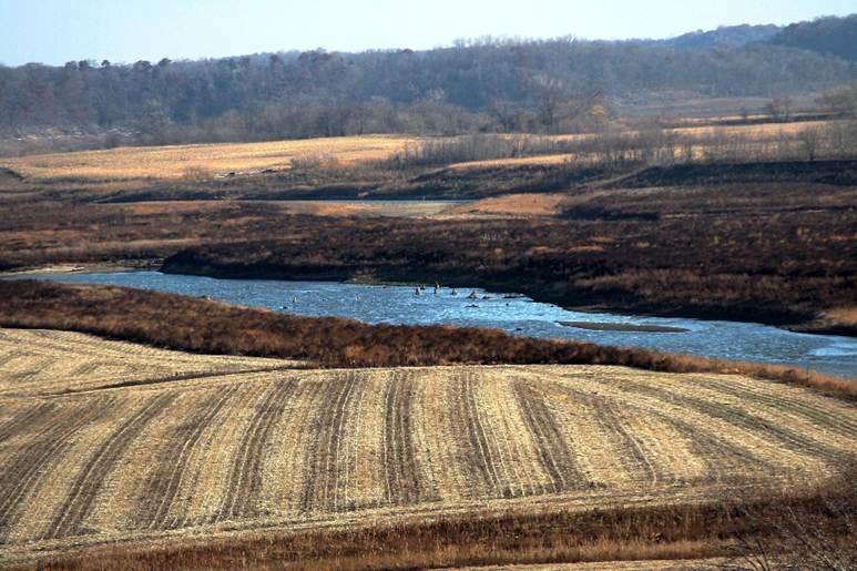
The Des Moines River at the High-Trestle Bridge, where the valley is much wider than today’s river could have made. When a river is underfit to its valley, other forces must have shaped the valley. In this case, flow from under the Des Moines Lobe glacier and outwash as the glacier’s front retreated made this valey over two miles wide.
In the highly altered land surfaces of Iowa, there are few, if any, natural creeks and rivers. The simplest reason is that post-settlement (1840s and after) land practices have steadily increased the volume of water delivered to a ravine, creek, or river. This increase alone has changed the channel depths and widths, lengthened the upstream stretches by eroding more channel, and resulted in higher movement of particles.
Weather changes over the last 150 to 200 years have exacerbated the effect with increased evapotranspiration from the leaves of crop plants, compared to prairie, wetland, and woodland species; that, in turn, tends to fuel stronger storms with increased rainfall. Only in the last two decades has Iowa seen a change toward heavy precipitation “events” with extended dry periods between, and downpours are responsible for rapid changes in surface and channel flow.
Despite lessons learned from the Dust Bowl in the Great Plains and declining soil fertility throughout the Midwest, soil erosion continues on cropped land, albeit at a slower rate than before World War 2. (See my four-part series in 2025, “The Land Goes Away” and “Bringing the Land Back.) Pastures often are closely grazed and trampled, leading to erosion on slopes, animal paths, and stream banks and crossings. Developed land leaks soil despite mandatory erosion controls because of poor installation and maintenance of silt fences, wattles, and other barriers. Impermeable surfaces and stormwater systems assure the rapid runoff of rain and snowmelt without a chance to permeate soil, and recent requirements for detention ponds only hold enough water to reduce flood peaks downstream.
A favorite target of criticism is field tile, installed in Iowa as long ago as the 1880s or so, and now experiencing a surge with perforated black plastic drains laid in a down-gradient pattern into a waterway. Beyond the tile, the receiving streams are blown out by the energy and volume of water.
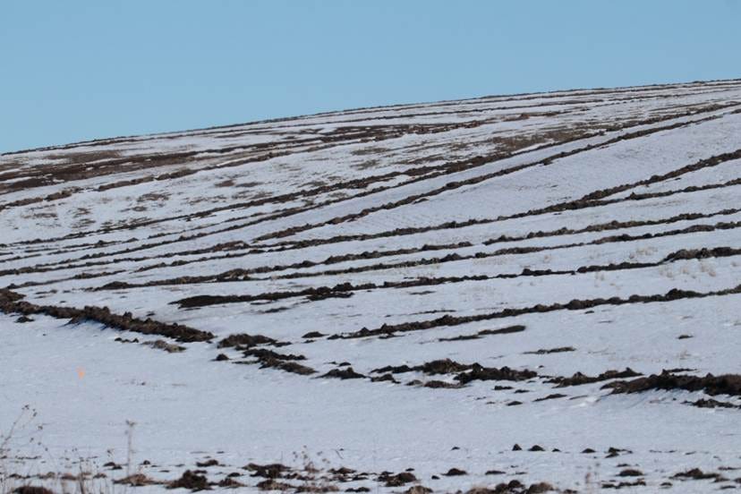
A “pattern-tiled” field with numerous parallel branch tiles flowing to a main tile below the center. Until the field is tilled, the ridges mark where a trenching machine excavated soil to about four feet and laid the black ABS plastic tile line at the same time.
We live heavily on the land and water here. In more detail, what is happening to our streams – creeks, ravines, and rivers – and how much might be stopped or reduced? As background, you might look back at earlier posts: “Urban Stream Syndrome” (June 23, 2025), “Stream Ecology” (May 11, 2025), and “How to Think Like a River” (May 1, 2025) for jargon and related science of stream hydrology.
Still, I need to burden you with some new technical definitions, starting with the size classes of sediment. If the sediment particle is large enough, it is measured along its intermediate (not longest or shortest or thinnest) axis, which is the axis that determines if it falls through or is trapped by a standardized sieve. Very fine particles are identified by sight (clay and silt) or by a combination of trained eye and texture, in the case of sands.
Measurements are usually in the metric system, although stream hydrology mixes metric and English system measurements. You might find a ruler or meter stick with metric units to imagine these. Even better, use the metric ruler to measure particles yourself. The size classes are:
Clay: equal to or less than .004 mm
Silt: between .004 and .062 mm
Sand: between .062 and 2 mm, with very fine, fine, medium, coarse, and very coarse subclasses; research has shown the breakdown crucial for accurate measurement of transport, load, and calculations from sediment sampling.
Gravel: between 2 and 64 mm, again with very fine, fine, medium, coarse, and very coarse subgroups.
Cobble: between 64 and 256 mm, with small, medium, and large.
Boulder: over 256 mm, with small, medium, and large.

A sorted and weighed sediment sample from an Iowa creek. The size classes present and the amount in each class are used to calculate sediment transport, stream competence (capacity to move the sediment in its channel), and other hydrological values.
Another rule of physics is that flowing water carries the smallest particles in suspension for the greatest distances, requiring the least amount of energy to do so. Even clay and sand can settle out in quiet water that is moving at snail’s pace. Increasing size means that the velocity and overall energy of the water must also increase. The stream’s power depends on amount of water given the channel size, the slope of the bed, obstacles, and shear stresses along the banks and bed. The sequence from low flow to flood peak to low flow also involves a change in power, and so streams sort their own sediments.
With so much surface erosion still ongoing in Iowa, the three soil particle sizes (clay, sand, silt) comprise the largest volume of sediments. Fast-moving water carries sand in all its subclasses until the velocity (and energy) decreases, with sand settling out in order of coarse to fine. As the flow continues to slow, silt drops out, and finally, clay.
Erosion
In a watershed, erosion occurs on almost every surface. A watershed includes slopes that provide energy (by gravity) to the flow. In many watersheds, the steepest bed slopes are at the highest altitude, and the flatter or lowest slopes occur where the tributaries have converged into a single flowing stream. It may occur to you that the size of a watershed is arbitrary, most likely based on some human need for management and measurement. A temporary watershed and channel can form on a sand beach during rain, amounting to a few dozen square feet, or a long-lasting, old watershed may consist of hundreds of thousands of square kilometers or square miles. The Mississippi Basin covers 444,000 sq. mi. (1,151,000 sq. km.).
A stream bed often has a set of features that are “engineered” by the water. In low-slope streams and rivers, this sequence is called a reach, and it has a riffle, a run, a pool, and a glide. These are idealized features, and any given river may have multiple shallow pools in one reach, and its riffles may consist of sand, gravel, cobble, or even boulder, if those sizes are available to it. Every flood moves at least the three smallest particle sizes downstream, sometimes removing and replacing tons of sand from a sand bar.
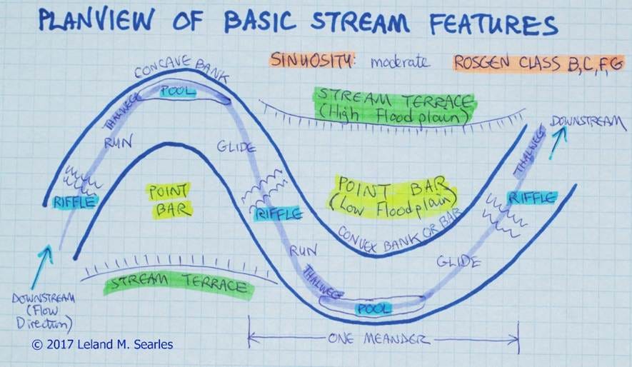
This bird’s-eye or planview diagram of a stream shows the riffle-run-pool-glide sequence, point bars, and terraces with steep banks. Note the direction of glow from left to right.
Streams with higher gradients have different sequences, such as a rapids-run-glide pattern with few or no pools, or little apparent difference in the bed because of boulders or bedrock.
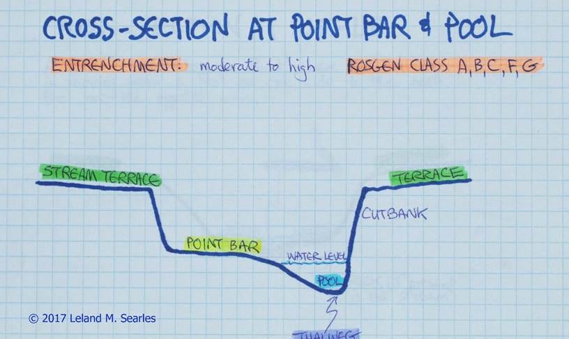
The channel banks can experience erosion differently compared to the bed. In slower, low-gradient streams with oxbow or S-meanders, the highest erosion happens on the outside of the bends, usually leading to a steep side with bare soil. Shallow floods tend to undercut these banks and cause slumping, while higher floods remove soil by scour. These banks are importance sources of sediment, depending on the proportions of particle sizes.
Opposite the outside curves, the water moves much more slowly, so sediment tends to be deposited there, forming a point bar. Deposition occurs mostly during the decreasing flow after the flood peak.
Many point bars in Iowa are actual sandbars, with the sand coming from surface erosion and bank scouring. Gravel bars also are formed when the stream is competent enough and gravel particles are available; I have seen gravel bars made from washed-out landscaping stone. Cobble bars are possible, and small boulders may occur on the surface or buried under finer sediments; remember, these sizes drop out first. One point bar may vary from cobble and gravel upstream to sand for most of its length, ending in a mucky clay-silt mess at the downstream end. Again, this happens because of decreasing velocity and power that effectively sort particles by size.
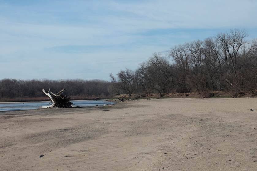
A massive sand bar on the Cedar River below Palisades-Kepler State Park, Iowa. Much of the sand and the size of the bar stem from human impacts on the land upstream.
Part Two follows in a few days.
Leland Searles
May 19 & 26, 2026